First 10 days on SPI (South Padre Island)
Now that we’ve been here for 10 days, we can give you a better description of where we are and what see in this part of the world.
SPI is on the very south end of a skinny, stretch of sandy islands that parallel the Gulf coast from the Texas-Louisiana border on the north end to the Texas-Mexico border in the south. This stretch of islands is in the shape of a crescent moon. Each of the islands that form this crescent shape has their own name.
When we started our adventure on this crescent moon, we chose not to start near the top ‘cause this is the Galveston area where Hurricane Ike left the area devastated. So, we started our adventure about mid-way down when we visited Mustang Island which is opposite Corpus Christi on the mainland. Immediately south of Mustang is Padre Island and this is a 65 mile (again sandy) finger stretch deemed a National Seashore Park. There is limited access to Mustang and Padre Islands and between the mainland and Padre Island. This Park protects the 350+ bird species that come to this area for the winter season – the Whooping Crane is one of them.
The Padre islands are separated from the Texas mainland by the Gulf Intracoastal Waterway and are called Laguna Madre. This bay is only about 4‘ deep except for the shipping channel. While the entire stretch is a safe-haven for waterfowl, there are boats offering dolphin-watching at every corner. The fishing must be tremendous ‘cause there are fishermen everywhere – standing hip-deep in the surf on the Gulf side and on the shores of the intracoastal. And in each community we’ve visited, the harbours have shrimp boats docked three-deep.
A small channel separates Padre Island from South Padre Island (SPI). Access to SPI is only from a town on the mainland called Port Isabel - pop of about 5000. A bridge/causeway brings you over to SPI. The bridge section is high enough at one point for large boats to pass underneath for the intracoastal. An amber warning signal sits on both sides of the approach to the bridge and there is a traffic light in the centre should pelican flight around the bridge become too active and crowded! Once you land on the island of South Padre, you are at the very southern tip. This is where the KOA is located and where we are stationed for the next month. The SPI strip (with hotels, big houses, restaurants, etc.) runs 10 miles north. The road then comes to an abrupt halt. The island continues another 20 miles north where there is only sand and beach and you can access this area only by driving on the beach. About 2,000 people normally make up the population until the March spring break when 50,000 students arrive over the causeway headed to the beach.
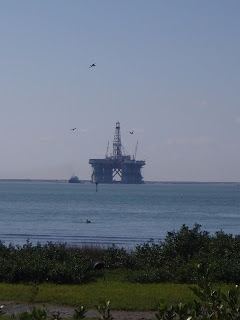
What’s so interesting is that, amongst this seashore look with its nature, palm trees, cactus plants and beach stores, you also see oil platforms and rigs. Here’s one that a barge pushed across Laguna Madre yesterday heading out to the Gulf.

Quite a mix of industry and nature! The Texans highly respect them both simultaneously. And, I might add, the Texans highly respect us “Winter Texans” recognizing the contribution made to the local economy.
More later about the people here and the weather… m.


0 Comments:
Post a Comment
Subscribe to Post Comments [Atom]
<< Home