Sunday, December 28, 2008

To Progresso, Mexico

About 10 days ago, we ventured to Progresso, Texas on our own in the Jeep. We had been advised to park our vehicle in a lot near the border and walk across. There were 2 lots immediately before the border and we parked at the one on the right. We read the lot signage carefully about their video surveillance (but couldn’t see any cameras) and theft (referring to the whole vehicle – not the contents). So, we took a photo of the Jeep thinking it may be the last time we saw it (her)!

We took the pedestrian walkway, paid our quarter to get into Mexico and looked back at the parking lot where the Jeep was located for as long as we could. We passed by a number of heavily-armed Mexican border guards. They were positioned behind a 6-ft high pyramid of sand bags and were pointing their automatic weapons into the market and the main street of Progresso, Mexico. We decided this would not be a good photo opp.

Within the next 10 blocks, we found 150+ pharmacies and 66 dentists offering their services out of store-front businesses. Each had a guy in the front doorway in a white medical coat trying to engage once of us in a conversation about why we needed their pharmaceutical or dental services. The sidewalk between the storefront and the street is covered to protect you from the sun. However, there is absolutely no protection from those trying to sell you souvenir trinkets, plastic toys, Indian blankets, gold that is not gold and black market CDs and DVDs. Here’s a pic to show you the street - I hope you can see what I mean:


About 8 blocks in, we came across a 4-storey building – 2 stories taller than most. Like the others, there was a pharmacy on the ground floor. Taking the elevator to the 4th floor, the door opened into an elegant restaurant with waiters in tuxes – completely opposite from the scene on the street. We had a super, true Mexican lunch for less than $20 and the best margs I’ve ever had! It's from the restaurant that I took the picture.

Even though we were on the 4th floor and, from there, the US border was in sight, the parking lot where our Jeep was located was NOT in sight. We were reminded of the estimated 4100 thefts of vehicles from Texas between Progresso and Brownsville and decided to get our butts back to the US pronto. So, we left the restaurant and zipped back to the border via the other side of the main street making no eye contact with any of the pharmacists, dentists or street vendors.

Passing through US Immigration and Customs was a breeze and we walked briskly back to the parking lot. Sure enough, the Jeep was there waiting for us – and were we ever glad to see her! So much so, we took the long way home winding our way alongside the Rio Grande – relieved that we were back on the US side and feeling a whole lot safer to be heading ‘home’ to South Padre. It’s my guess that was probably our last trip to Progresso.

Thursday, December 25, 2008

Feliz Navidad!

We woke up yesterday morning missing home, family and friends. (And yes, I know "home" has been experiencing lots of snow, high winds and terrible driving conditions.) We talked throughout the day about how we felt something was missing. We also talked about it with others here in the park - people from Nova Scotia, Michigan, Wisconsin, Indiana and Minnesota. Everyone agreed the snow brings an ambience to the season and, of course, everyone recalled memories of Christmases past with our families and friends. It was almost the sole topic of conversation at the Xmas Eve bonfire we attended last night.

And this morning when we woke up to Christmas in Texas, we felt the same. We felt sad we were missing 2 sons, a daughter and daughter-in-law, 2 grandkids, 3 nephews and their wives and kids, a niece, a sister and her beau, and so many close friends in Kingston, from Orillia, Ottawa, Russell, Manotick, PEI and many other places. We opened our presents, had our Christmas breakfast together quietly and it was only 9:00 am.

And then we went outside and it was 80 degrees! and suddenly, we didn't feel so bad (lol)... it's 85 degrees now so I'd say we're over it completely! We checked this aft with those in the park from Nova Scotia, Michigan, Indiana and Minnesota and, you know what? Amazingly, they're over it too!

As a matta of fact, we hope y'all's en-joying your Christmas wherever you are hitched up for the Day and trust Ol' Santa brought y'all somtin gooood... Hope y'all's eatin' turkey and chowin' down those taters, yams and dee-sserts like pee-can pye! We'll check back witcha in a few days - in the mean time, Merry Christmas to y'all and to y'all a Good Night! Yessir... Feliz Navidad!

Sunday, December 14, 2008

The Weather and the Wind

Most of our days in the past 2 weeks have been in the higher 70’s and 80’s. A few days in each of the two weeks have been in the 60’s. Consistently, the sky is blue with almost no clouds and we have had no rain. What is remarkable is the wind – apparently a winter phenomenon with almost no wind to report in the summer months.

The winds come mostly from the Gulf (from the SSE) and this makes the days warm. When they come from the interior of Mexico and Texas (NNW), they make the temp drop. But no matter which direction they come, they average 15-20 mph. There are strong gusts in the afternoon running the speed up to 30-35 mph. We had not had our awning out yet. Here's a pic I took yesterday aft - check out the palm trees:


You know how the Weather Channel depicts an increasing number of rain droplets for the amount of rain you can expect, or how they depict the sun with a few clouds. Well, for SPI, there is only the word WINDY in block letters. And windy it is, believe me. A walk on the beach is sure to offer a fine coating of salt. We have already had the bus professionally washed.

On Tuesday night this week, we had a beautiful evening after dinner and headed to bed with the temp at 71 degrees. Surprisingly, the winds were low and a number of us commented on that. But by 10:30 pm, we could hear the winds picking up and, by midnight, were feeling the strength of the gusts. For me, it was like being in our boat at a dock during a storm - when when the lines jerk the boat back to the dock with each wave. For Johnnie, it was like trying to sleep on a moving train. And, when we got up in the morning, the temp was 40 degrees! And even on that day, the kite-surfers were out on the Gulf! There is always something for everyone!

However, this captain was not so lucky when his engine failed out on the Gulf and his vessel landed on the jetty at Boca Cica Beach. The stern is (almost) separate from the hull and lies on the other side of the jetty. This only happened 2 weeks ago Friday - a sad day for that captain, I'm sure.

Thursday, December 11, 2008

The US-Mexico Border

The communities in our area stretch from Port Isabel on the mainland (pop 5000) west about 30 miles to Brownsville (pop 140,000) which is the border crossing. The Mexican city adjacent to Brownsville is Matamoras (pop 850,000) and the two cities are separated by the Rio Grande River. Now the Rio Grande is not wide like we had thought - we were surprised to find it was only about 100’ across right at the highway border crossing. We had an image of this HUGE river in our minds – probably from all those John Wayne movies!

To offer you a sense of what crossing the border was like – well, congested is the word that best describes it. We signed up for a day tour and were 13 in a van when we crossed one of the 3 entry points at Brownsville into Matamoras, Mexico. The tour operator clearly had some type of pre-approved entry pass. We drove very slowly through a short, narrow corridor (almost felt like a tunnel but it wasn’t) and suddenly, we were on the city streets and in the crowded city market of Matamoras. You would never know you even crossed the border - except for the 6 heavily armed guards lining the walls of that corridor. The streets in the downtown core were narrow and overly congested with parked cars on either side of the streets and people crossing hither and fro at will - and no English on the signage or in the market stores.

We re-entered the US at a different crossing into Brownsville with 5 primary lines – no transports, only cars. We waited in line about 30 minutes and our tour operator brought all the liquor and meds (half-price for Americans) to the front of the vehicle – there was no interest in my $15 shoes! The US officer opened the passenger side doors, checked our Immigration papers and passports carefully and compared them to each of our faces. He released us from that point to a narrow corridor where we slowly passed a K-9 shepherd with his handler – the dog sniffing at the door frames of the van as we drove by. Next stop was the Texas Liquor Commission booth to pay $1.25/imported bottle of liquor. The stop sign onto the streets of Brownsville were less than 10 feet away.

An interesting day! Will we ever drive across to Matamoras ourselves? No way – the congestion creates such a feeling of uneasiness and a real sense of criminal activity. Will we consider going further (about 20 miles) up the Rio Grande and cross into Mexico at Progresso? Probably – we’ve been told it is way less congested and safer. Will we cross at Progresso with our Jeep? No way – we’ve been told ‘it’s best’ to park your car in Texas and walk across.

Sorry there are no pics – they do not permit any to be taken at the US border itself – a change since September 11th.

And back at South Padre, there is a US Coast Guard Station close enough to us that we can hear the final bugle post when the sun and flag go down. The US Customs and Border Patrol Services operate their marine service from here. We have seen one of their boats - a 32' Donzi centre-console with a hard-top and four 250 hp Mercs on the back! It’s a busy area for smuggling, I’m sure – guns going south and people and drugs coming north.

Life at the border – a bit different than where I was raised at Sault Ste. Marie!

First 10 days on SPI (South Padre Island)

Now that we’ve been here for 10 days, we can give you a better description of where we are and what see in this part of the world.

SPI is on the very south end of a skinny, stretch of sandy islands that parallel the Gulf coast from the Texas-Louisiana border on the north end to the Texas-Mexico border in the south. This stretch of islands is in the shape of a crescent moon. Each of the islands that form this crescent shape has their own name.

When we started our adventure on this crescent moon, we chose not to start near the top ‘cause this is the Galveston area where Hurricane Ike left the area devastated. So, we started our adventure about mid-way down when we visited Mustang Island which is opposite Corpus Christi on the mainland. Immediately south of Mustang is Padre Island and this is a 65 mile (again sandy) finger stretch deemed a National Seashore Park. There is limited access to Mustang and Padre Islands and between the mainland and Padre Island. This Park protects the 350+ bird species that come to this area for the winter season – the Whooping Crane is one of them.

The Padre islands are separated from the Texas mainland by the Gulf Intracoastal Waterway and are called Laguna Madre. This bay is only about 4‘ deep except for the shipping channel. While the entire stretch is a safe-haven for waterfowl, there are boats offering dolphin-watching at every corner. The fishing must be tremendous ‘cause there are fishermen everywhere – standing hip-deep in the surf on the Gulf side and on the shores of the intracoastal. And in each community we’ve visited, the harbours have shrimp boats docked three-deep.

A small channel separates Padre Island from South Padre Island (SPI). Access to SPI is only from a town on the mainland called Port Isabel - pop of about 5000. A bridge/causeway brings you over to SPI. The bridge section is high enough at one point for large boats to pass underneath for the intracoastal. An amber warning signal sits on both sides of the approach to the bridge and there is a traffic light in the centre should pelican flight around the bridge become too active and crowded! Once you land on the island of South Padre, you are at the very southern tip. This is where the KOA is located and where we are stationed for the next month. The SPI strip (with hotels, big houses, restaurants, etc.) runs 10 miles north. The road then comes to an abrupt halt. The island continues another 20 miles north where there is only sand and beach and you can access this area only by driving on the beach. About 2,000 people normally make up the population until the March spring break when 50,000 students arrive over the causeway headed to the beach.

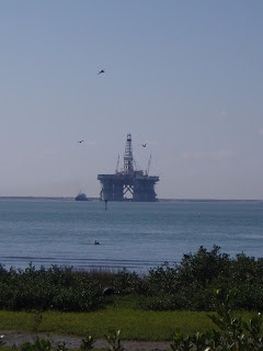
What’s so interesting is that, amongst this seashore look with its nature, palm trees, cactus plants and beach stores, you also see oil platforms and rigs. Here’s one that a barge pushed across Laguna Madre yesterday heading out to the Gulf.


Quite a mix of industry and nature! The Texans highly respect them both simultaneously. And, I might add, the Texans highly respect us “Winter Texans” recognizing the contribution made to the local economy.

More later about the people here and the weather… m.